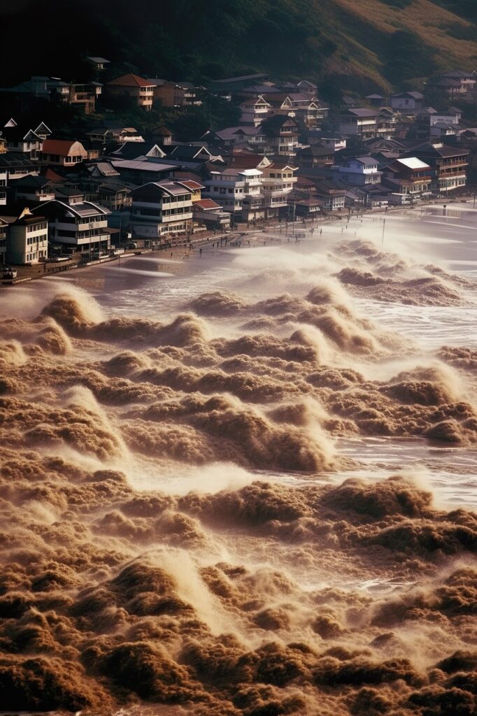
The image is primal, terrifying, and devastatingly final: a towering wall of water, unstoppable and indiscriminate, swallowing coastlines whole. A tsunami represents one of nature’s most formidable forces, capable of unleashing destruction measured in thousands of lives and billions of dollars within minutes. For centuries, humanity faced these events with little more than raw fear and reactive desperation. Survivors’ tales spoke of the ocean receding mysteriously, the only warning before the cataclysm hit.
But the narrative is shifting. Dramatically. We are no longer solely at the mercy of the waves. A silent revolution, driven by unprecedented technological innovation, is transforming how we predict, detect, warn, respond to, and ultimately survive tsunamis. This isn’t science fiction; it’s the hard-won frontier of geoscience, computing, communications, and robotics converging to create a digital lifeline against the ocean’s rage.
I. The Anatomy of a Catastrophe: Understanding the Tsunami Beast
Before diving into the tech, understanding the enemy is crucial. A tsunami (from the Japanese “harbour wave”) is not a single wave but a series of powerful ocean waves generated by the rapid displacement of massive volumes of water. Unlike wind-driven waves affecting the surface, a tsunami energizes the entire water column, from seabed to surface.
The Triggers:
Submarine Earthquakes (The Primary Culprit): Sudden vertical movement along tectonic plate boundaries (especially subduction zones like the Pacific “Ring of Fire”) displaces vast amounts of water overhead. Magnitude 7.0+ quakes are typically needed.
Submarine Landslides: Earthquakes or collapsing sediment slopes can trigger massive underwater landslides, displacing water.
Volcanic Eruptions: Explosive eruptions (e.g., Krakatoa 1883, Hunga Tonga–Hunga Haʻapai 2022) can displace water directly or trigger landslides/caldera collapses.
Meteorite Impacts: Extremely rare but potentially catastrophic on a global scale.
The Physics of Fury: Energy radiates outward from the source at jetliner speeds (500-800 km/h in deep ocean). As waves approach shallow coastlines, they slow dramatically (down to 30-50 km/h), but their height builds ferociously. The first wave isn’t always the largest; successive waves can arrive minutes to hours later.
The Devastation: Impacts include:
Inundation: Massive flooding far inland.
Strong Currents: Capable of sweeping away buildings, vehicles, and people even in relatively shallow water.
Debris Impact: Transforming everyday objects into deadly projectiles.
Erosion: Undermining foundations and reshaping coastlines.
Saltwater Contamination: Destroying farmland and freshwater supplies for years.
II. The First Line of Defense: Detection and Early Warning Systems – A Global Nervous System
The critical factor in tsunami survival is time. Early warning systems are the technological backbone of global defense.
Seismic Networks: The First Alert
Advanced Sensors: Global networks (like the USGS’s ANSS, Japan’s Hi-net) deploy highly sensitive seismometers (accelerometers, broadband sensors) on land and seafloor.
Real-Time Analysis: Algorithms analyze seismic waveforms within seconds, automatically estimating location, depth, and magnitude. Distinguishing a potential tsunami-generating earthquake (shallow, large magnitude, thrust mechanism) from other quakes is paramount. Machine Learning (ML) is increasingly used to improve speed and accuracy of these determinations.
Limitations: Seismology tells us an earthquake happened and its potential to cause a tsunami, but not the actual wave size. Confirmation comes from the ocean itself.
The Ocean’s Pulse: Tsunami Detection Buoys (DART)
How DART Works: The Deep-ocean Assessment and Reporting of Tsunamis system is the gold standard. Anchored buoys in deep water (6,000m+) house highly sensitive Bottom Pressure Recorders (BPRs) on the seafloor. These BPRs detect the minute pressure changes caused by a tsunami wave passing overhead (mere centimeters high in deep ocean!).
Real-Time Satellite Relay: Data is transmitted acoustically from the BPR to the surface buoy, then relayed instantly via satellite to warning centers.
Strategic Placement: Networks like NOAA’s (US), Australia’s, and regional systems in the Indian Ocean and Caribbean are strategically placed near subduction zones. The 2004 Indian Ocean tsunami tragically highlighted the need for a truly global network, which has since expanded significantly.
Evolution: Newer DART systems feature two-way communication for reconfiguration and higher data sampling rates. Research into more cost-effective buoy designs and alternative deployment methods is ongoing.
Coastal Tide Gauges: Confirming Arrival
Network Integration: Thousands of coastal tide gauges worldwide (part of the Global Sea Level Observing System – GLOSS) provide crucial real-time data as a tsunami approaches shore. They confirm wave arrival time, height, and duration, refining warnings for specific locations downstream.
Modernization: Legacy gauges are being upgraded with radar and acoustic sensors for greater accuracy and reliability, transmitting data in real-time via satellite or cellular networks.
The Nerve Centers: Tsunami Warning Centers
Global Coordination: Key centers include:
Pacific Tsunami Warning Center (PTWC), Hawaii: Covers the Pacific and most of the world.
Northwest Pacific Tsunami Advisory Center (NWPTAC), Japan: Focuses on Japan, Russia, Korea.
National Tsunami Warning Center (NTWC), Alaska: Covers US and Canadian coastlines.
Indian Ocean Tsunami Warning and Mitigation System (IOTWMS) Centers (India, Indonesia, Australia).
Caribbean Early Warning System (CREWS) Center.
The Decision Engine: Warning centers ingest seismic, DART, and tide gauge data in real-time. Sophisticated software models (like NOAA’s MOST – Method of Splitting Tsunamis) simulate wave propagation, predicting arrival times and potential heights at thousands of coastal points. Artificial Intelligence (AI) is now augmenting these models:
Faster Scenario Matching: AI quickly compares incoming data against vast libraries of historical and simulated tsunami scenarios.
Improved Forecasting: ML algorithms analyze complex wave interactions with coastlines, potentially offering more precise localized forecasts.
Uncertainty Quantification: AI helps estimate the confidence level of predictions, aiding decision-making for warnings.
The Critical Call: Based on all data and models, warning centers issue bulletins:
Tsunami Warning: Dangerous coastal flooding and powerful currents imminent. Full evacuation recommended.
Tsunami Advisory: Strong currents dangerous to swimmers/boats likely. Stay out of water, away from shore.
Tsunami Watch: Potential threat still being evaluated.
Information Statement: Earthquake occurred, no threat or very minor threat.
Decision Support: Visualization dashboards integrate all data streams, model outputs, and population maps, allowing duty scientists to make rapid, informed judgments under extreme pressure.
III. Getting the Word Out: Dissemination – The Race Against Time
A perfect warning is useless if it doesn’t reach people in harm’s way. Technology bridges this last, vital mile.
Emergency Alert Systems (EAS): Integrated national systems that interrupt radio, TV, and cable broadcasts with loud, distinctive alerts. Mobile network integration (Wireless Emergency Alerts – WEA) is critical, pushing text-like alerts to all compatible phones in a threatened area, regardless of subscription. Challenges: Ensuring coverage, preventing desensitization, clear multilingual messaging.
Cell Broadcast: A superior technology for mass mobile alerts. Unlike SMS, it doesn’t get congested and delivers near-instantly to every phone on a cell tower. Adoption is rapidly increasing globally.
Satellite Communication: Essential for reaching remote islands, vessels at sea, and areas where terrestrial networks fail. Systems like Inmarsat and Iridium provide critical backup.
Social Media & Apps: Official agencies (@NWS_Tsunami, @JMA_tsunami_info) use platforms like Twitter/X and Facebook for rapid updates. Dedicated tsunami warning apps (e.g., Japan’s Yurekuru Call, US NOAA Tsunami Alert) deliver location-specific alerts and information. AI plays a role in monitoring social media for ground-truth reports and combating misinformation.
Sirens & Local Networks: Traditional but vital, especially in coastal communities. Modern systems are often IP-based, allowing remote activation and integration with central warning systems. Community radio and loudspeaker networks operated by local authorities or NGOs remain crucial.
The Future:
Targeted Geo-Fencing: Hyper-local alerts sent only to phones physically within the precise inundation zone.
Integration with Smart Devices: Alarms on smart speakers, displays on smart TVs, notifications on wearables.
Multimodal Delivery: Ensuring alerts come through multiple channels simultaneously (phone buzz, siren, broadcast interruption, app notification) for maximum impact.
IV. Eyes in the Sky and Sea: Monitoring & Modeling – Seeing the Unseen
Beyond immediate warnings, technology provides unprecedented views of tsunami events for research and future preparedness.
Satellite Radar Altimetry: Satellites like Sentinel-6 Michael Freilich and the Jason series use radar to measure sea surface height with centimeter accuracy. They can directly detect the broad-scale signature of a tsunami wave propagating across the open ocean, validating model predictions and DART data. Crucial for tracking waves heading towards distant coastlines.
Synthetic Aperture Radar (SAR): Satellites like Sentinel-1 can image ocean surface roughness. While not directly measuring height, SAR can detect the characteristic patterns associated with tsunami currents and fronts, especially near shore, providing another layer of confirmation.
High-Resolution Coastal Mapping (LiDAR): Airborne Light Detection and Ranging creates incredibly detailed 3D maps of coastlines. This data is fundamental for accurate tsunami inundation modeling, identifying vulnerable areas, planning evacuation routes, and designing resilient infrastructure.
Advanced Numerical Modeling:
Higher Resolution: Leveraging supercomputers to run models with finer grids, capturing complex coastal bathymetry and topography more accurately.
Stochastic Modeling: Running thousands of simulations with slightly varying earthquake parameters to understand the range of possible tsunami impacts and probabilities (“Probabilistic Tsunami Hazard Assessment” – PTHA).
Real-Time Data Assimilation: Continuously feeding DART and tide gauge observations into running models to correct and refine forecasts as the event unfolds (similar to weather forecasting).
AI/ML Acceleration: Using machine learning to create faster, surrogate models (“emulators”) of complex physics-based simulations, enabling rapid scenario testing or even near real-time probabilistic forecasting during an event.
V. When the Wave Hits: Response and Recovery – Tech in the Rubble
The tsunami has struck. Now technology shifts focus to saving lives amidst chaos and rebuilding.
Search and Rescue (SAR):
Drones (UAVs): Revolutionizing SAR. Equipped with high-res cameras, thermal imaging, and LiDAR, drones provide rapid aerial assessment of vast, inaccessible, or hazardous flooded areas. They locate survivors, identify hazards (gas leaks, unstable structures), map debris fields, and guide ground teams. AI-powered image analysis can automatically flag potential signs of life (heat signatures, movement) in vast amounts of drone footage.
Satellite Imagery: Commercial providers (Maxar, Planet Labs) and agencies (Copernicus Emergency Management Service) task satellites immediately post-disaster. High-res optical and radar images reveal the full extent of flooding, damage to infrastructure (ports, roads, power lines), and blocked access routes, coordinating overall response.
AI-Powered Damage Assessment: ML algorithms analyze pre- and post-event satellite/drone imagery to automatically categorize building damage levels (destroyed, major, minor), accelerating the targeting of aid and resources.
Cellular Network Analysis: Aggregated, anonymized mobile phone location data can help estimate population displacement and identify areas where large numbers of people might be trapped or congregated.
Communication Restoration:
Deployable Systems: Flying Cell on Wings (COWs) or Cells on Light Trucks (COLTs) provide instant mobile coverage. Portable satellite terminals (VSATs) restore internet for emergency coordination centers. Mesh networks can be set up locally where infrastructure is destroyed.
Low Earth Orbit (LEO) Satellite Constellations: Starlink, OneWeb, and Project Kuiper are game-changers. Portable user terminals can be rapidly deployed to provide high-speed internet virtually anywhere, restoring vital comms for responders and affected communities much faster than traditional methods.
Coordination and Logistics:
GIS Platforms: Geographic Information Systems (like ArcGIS Online) become mission control. Integrating real-time drone/satellite data, damage assessments, resource locations (shelters, hospitals, supply depots), and responder positions onto dynamic maps enables unprecedented situational awareness and coordination.
Blockchain for Aid: Exploring secure, transparent tracking of donations and supplies from source to beneficiary, reducing fraud and ensuring efficiency.
Public Information & Reunification:
Crisis Mapping & Crowdsourcing: Platforms like Ushahidi allow citizens to report needs, hazards, or sightings via SMS or web, aggregating vital ground-level intelligence.
Safe & Well Registries: Online platforms (e.g., Red Cross) allow survivors to mark themselves safe and families to search for loved ones.
Social Media Verification: Teams use specialized tools to identify and amplify credible information sources while flagging misinformation circulating online.
VI. Building Back Smarter: Mitigation and Resilience – Tech for the Long Haul
Surviving the next tsunami requires building smarter before it happens.
Precision Hazard Mapping: Combining LiDAR topography, detailed bathymetry, and advanced PTHA models to create highly accurate inundation maps. These inform land-use planning, building codes, and evacuation zones. AI helps analyze complex datasets to identify subtle vulnerabilities.
Smart Infrastructure:
Tsunami-Resilient Design: Engineering innovations using computational fluid dynamics modeling to design buildings that allow water to flow through ground floors (breakaway walls), elevated critical infrastructure, and strategically placed seawalls/berms.
Sensor-Embedded Structures: Monitoring the health of sea walls, bridges, and critical buildings for early signs of stress or needed maintenance.
Nature-Based Solutions: Using technology (drones, satellite monitoring) to map, plan, and monitor the restoration of coastal ecosystems like mangroves, coral reefs, and dunes, which provide natural tsunami buffers.
Virtual Reality (VR) & Simulation Training: Immersive VR simulations train emergency managers, first responders, and even the public on evacuation procedures and response protocols in a safe, repeatable environment.
Community-Based Early Warning: Technology empowers local communities. Simple, rugged sensors linked to solar-powered sirens or local radio networks provide vital seconds or minutes of warning, especially where national systems might be slower to reach. Training on recognizing natural signs (earthquake shaking, unusual sea recession) remains crucial.
VII. The AI & Big Data Frontier: The Next Wave of Tsunami Tech
The future of tsunami resilience is inextricably linked to artificial intelligence and the vast oceans of data we now collect.
Predictive AI: Moving beyond detection towards probabilistic forecasting. Could AI identify subtle precursors in seismic, oceanographic, or even atmospheric data that hint at an increased likelihood of a major tsunami-generating earthquake in the coming weeks or months? Research is highly active but remains in the exploratory phase.
Automated Threat Assessment: AI continuously analyzing global seismic, DART, and satellite data streams in real-time, triggering alerts faster than human operators and running initial impact simulations before the warning center phone rings.
Hyper-Local Inundation Forecasting: Using ML trained on high-resolution simulations and real-world data to predict street-by-street flooding within minutes of an earthquake, enabling micro-targeted evacuations.
Optimizing Sensor Networks: AI algorithms determining the optimal placement of new DART buoys or seismic sensors to maximize warning time for vulnerable populations.
Social Media Sentinel: Advanced NLP (Natural Language Processing) AI constantly monitoring social media globally for keywords and images related to earthquakes and unusual wave activity, providing potential ground-truth confirmation or early alerts faster than official channels in some remote scenarios (with careful verification to avoid false alarms).
Big Data Fusion: Integrating diverse datasets – seismic history, seafloor topography, coastal land use, population density, real-time sensor feeds, weather patterns – into unified AI models for a holistic understanding of risk and response.
VIII. Case Study: Japan – Living on the Edge, Leading in Tech
No nation embodies the tsunami challenge and technological response like Japan. Sitting atop the volatile Pacific Ring of Fire, its history is scarred by devastating waves (2011 Tohoku being the most recent and catastrophic).
Dense Sensor Networks: World’s densest seismic and GPS networks. Hundreds of offshore cabled observatories with seismometers and pressure sensors directly on the seafloor near the trench, providing the fastest possible detection. An extensive DART and coastal tide gauge network.
Sophisticated Modeling: JMA (Japan Meteorological Agency) uses cutting-edge, high-resolution models assimilating real-time data. They issue detailed forecasts within minutes, including expected maximum heights at specific coastal points.
Rapid Dissemination: J-Alert system blasts warnings via sirens, TV/radio interruption, cell broadcasts (Area Mail), and dedicated apps instantly. Extensive public education and regular drills.
Engineering & Resilience: Massive sea walls (though debated), designated vertical evacuation towers in coastal towns, strict building codes in inundation zones, and widespread public awareness.
Lessons from 2011: The Tohoku disaster drove massive technological upgrades: more offshore sensors, higher sea walls in critical areas, improved backup power for warning centers, enhanced community evacuation planning, and research into mega-thrust earthquake mechanics. The focus shifted to resilience beyond just defense.
IX. Challenges and the Road Ahead: Fortifying the Digital Lifeline
Global Equity: The most advanced systems are expensive. Ensuring robust warning capabilities for vulnerable developing nations and Small Island Developing States (SIDS) requires sustained international funding, technology transfer, and capacity building (e.g., UNESCO IOC’s initiatives).
False Alarms & “Cry Wolf”: Every false alarm erodes public trust. Improving forecast accuracy (especially for non-seismic tsunamis like landslides) and refining warning thresholds using AI-driven probabilistic approaches is critical.
The “Last Mile” Problem: Technology delivers the warning, but human action saves lives. Ensuring alerts are understood, believed, and acted upon requires continuous, culturally sensitive public education, drills, and community engagement. Technology must be accessible (e.g., multilingual alerts, accessible formats).
Maintenance & Sustainability: Buoys break, sensors drift, systems need updates and power. Robust funding and protocols for maintaining global networks are non-negotiable.
Data Sharing & Interoperability: Seamless, real-time data exchange between national and international agencies during a crisis is vital but can face political or technical hurdles. Standardized formats and protocols are essential.
Climate Change: Rising sea levels mean future tsunamis will penetrate further inland, increasing the inundation zones mapped years ago. Models and hazard assessments must continuously integrate updated sea-level projections.
X. What You Can Do: Be Tech-Ready for the Unthinkable
Technology is powerful, but individual preparedness is irreplaceable. Leverage tech to protect yourself and your family:
Know Your Zone: Use official apps or websites to find out if you live, work, or play in a tsunami hazard zone. Understand local evacuation routes (on foot! Roads may be jammed or destroyed).
Enable Emergency Alerts: Ensure Wireless Emergency Alerts (WEA) are activated on your phone. Download official tsunami warning apps (e.g., NOAA Tsunami Alert, local equivalents like Yurekuru Call in Japan). Follow official agency social media accounts (@NWS_Tsunami, local equivalents).
Have a Plan: Discuss and practice your family evacuation plan. Identify a safe meeting place on high ground. Know your kids’ school/care center plans.
Prepare a Kit: Have a “go-bag” ready: water, non-perishable food, meds, first aid, flashlight, batteries, radio, cash, copies of important docs, sturdy shoes. Consider water purification tech (tablets/filters).
Heed Natural Warnings: FEEL a strong/long earthquake near the coast? SEE the ocean recede unusually far? HEAR a loud roar from the ocean? DON’T WAIT FOR AN OFFICIAL ALERT. Evacuate immediately inland or to high ground.
Stay Informed: After a warning, listen to official sources (battery-powered radio, official apps, trusted news sites) for updates and the “all clear.”
Conclusion: From Fear to Foreknowledge
The shadow of the tsunami will always loom over coastal communities. The raw power of the ocean remains humbling and terrifying. However, the trajectory of technological advancement offers profound hope. We are moving from an era of passive dread to one of active, informed resilience.
The digital lifeline woven from seismic sensors, deep-sea buoys, orbiting satellites, supercomputers, AI algorithms, and instant communication networks is growing stronger and smarter by the day. It’s a testament to human ingenuity in the face of nature’s most extreme challenges. This technology doesn’t prevent the earthquake or calm the wave, but it grants us the most precious commodity: time. Time to flee, time to warn others, time to survive.
The mission is clear: relentlessly advance this technology, ensure its equitable global deployment, maintain it vigilantly, integrate it seamlessly, and empower every individual to act upon its warnings. By harnessing the power of innovation, we transform the narrative of the tsunami from one of inevitable tragedy to a story of survival, resilience, and hope. The next wave is coming. Thanks to technology, we will be more ready than ever before.